April 9, 2011
A few of my Meteorology friends and I were seriously thinking of going chasing today. We had been watching the weather models all week long (since Sunday), and they were indicating a big severe weather outbreak in Nebraska (NE) and Iowa (IA). As the week progressed, the models began agreeing with each other, which does not happen too often. On Wednesday, we made the decision to go storm chasing on April 9 because everything was looking very promising. Even from 3 days out, the SPC (Storm Prediction Center), had our target area of W IA/E NE under a “moderate risk” for severe weather. This was very good for this time of year, but we still had our doubts about what would happen. Whenever severe weather occurs this early in the season, the storms move extremely fast, and that makes those storms very hard to chase. Anyway, the set-up for April 9 was very good, as there was a large amount of CAPE (gasoline for storms) available in the atmosphere. This meant there was plenty of instability to get storms to fire. In addition, moisture was also readily available, thanks to warm/moist advection from the Gulf of Mexico. There was also plenty of wind shear, which allows the storms to become tilted and become supercellular. Finally, we knew a lifting mechanism (something to get the initial clouds to form) would be available because temperatures were fore-casted to be in the upper 80s and low 90s for our target area. With all these in mind, we had the 4 ingredients necessary for severe weather; instability, moisture, wind shear, and a lifting mechanism.However, there was another issue that we saw could pose a problem, and that was the “atmospheric cap.” Think of this term as a bottle of pop. If the lid is completely screwed on the bottle and you shake it up, what will happen? With the exception of the pop getting very agitated, it will not leave the bottle. Now, what happens when you shake up this same bottle and remove the lid? KABLOOEY!!! The same can be said for our atmosphere on a day when severe weather is probable. If the atmospheric cap is too strong, the clouds won’t be able to break through, and severe weather will not happen. When storms do form, they will die almost instantly. On the other hand, if the cap is too weak, storms will fire too soon and will die almost instantly. The key here is to have a strong, but breakable, cap. This will allow the atmosphere to “cook”, and when it cooks long enough, KABLOOEY!!!
On the morning of April 9, the four of us met at the NIU parking garage, and we left DeKalb around 9:15 AM. We headed west toward Omaha, NE, as this was our initial target city. After stopping in Des Moines, IA for lunch about 4 hours later, we continued our trek west to Omaha. We stopped at a gas station to fill up and for a pit stop. After we looked at weather data again, we decided to head north toward Blair, NE, where we would once again figure out what we would do. We noticed cloud towers going up in the distance, which was a sign that the cap was starting to break. Each tower got higher than the previous one, and it was not until the 5th tower went up when we knew something big was about to happen. Needless to say, we started heading East to follow the newest tower, and it certainly took its time to develop into what would eventually be a supercell. We got very excited when this tower turned into a thunderstorm and was placed under a severe thunderstorm warning for 1” hail. This cell was eventually placed under a tornado warning, as Doppler radar indicated very strong rotation within the storm. We passed through Decatur, NE, on our way to Mapleton, IA and the storm produced a tornado near Decatur after we had left. Being that this storm was moving east, like we were, we did not get too concerned.
 |
| photo by Justin Pletsch |
When we were about 2 miles west of Mapleton, we stopped for a brief moment to see what this storm was going to do. Obviously, this storm was already a supercell, and it was a beast!!! There were four areas of rotation inside this storm, and they were all rotating around each other. It was really neat to see this on radar, as it looked like a miniature hurricane. At this point, this storm was beginning to drop hail the size of quarters, half-dollars, AND ping pong balls. We decided to head into Mapleton to seek shelter from the hail, so we found a BP gas station and chose to play the waiting game. Our position was perfect, and we would soon realize just how perfect it really was. The sirens were blaring in the town, which was a very good sign. As we were gawking and taking pictures of the storm, the gas station power went out. Our initial thought was that lightning must have struck some power lines.
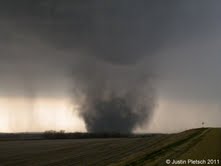
 |
| photos by Justin Pletsch |
It was at this point when the rotating part of the storm (the mesocyclone) came right over us, and we noticed a “bulge” protruding from the base of this monster. This “bulge” was a funnel cloud if you were to view it from a distance. Soon after this feature was pointed out, we saw dust getting picked up about 200 yards away from us. THAT, ladies and gentlemen, was the tornado ON THE GROUND!!! I have never seen 4 people get into a car as fast as we did, and our hearts were beating faster than ever!! We thought about taking shelter in a car wash that was nearby, but we decided to get out of town as fast as we possibly could. For a few minutes, WE were the ones being chased by the tornado, which turned out to be an EF-3 monster (3/4 of a mile wide). We stopped VERY quickly to take pics/video of this before we continued to high-tail it out of harm’s way. However, we got caught between the hail core (dumping baseballs at this point) and the tornado, so we spent what seemed like an eternity trying to get away. Yes, it was raining, and we knew we were close to the core when we heard a loud BANG on the car. This was because we were getting pelted by baseballs, so it made the situation even worse.
 |
| tornado on ground photo by Justin Pletsch |
After the tornado dissipated, we started to head toward Fort Dodge, IA, where we would be spending the night. On our way there, we encountered ANOTHER tornado, and I was fortunate enough to get a very brief video of it. At this point, darkness had come upon us, so we had to rely on the frequent lightning strikes to see what was happening. We also noticed what appeared to be a very low hanging wall cloud (hills were obstructing our view). The next morning, we found out that this “low hanging wall cloud” was actually a 2.5 mile wide tornado that stayed in the fields. We followed this storm to Sac City, IA, and watched as it went through Pocahontas, IA, and dumped grapefruit sized hailstones on the town. In fact, before it went through, the storm had 2 tornadoes on the ground at once!!! After enjoying an amazing display of lighting, we finished our trek west toward Fort Dodge. All in all, this was a very exhilarating chase, even though we came very close to meeting Death face-to-face.
As for the town of Mapleton, 60% of it was completely destroyed by the tornado that went through (including the car wash we were thinking of taking shelter in). Despite all that, no one perished because of the 20 minute lead time they had. The worst injury was a broken leg. This storm was known as a “cyclic supercell”, which means it produced tornado after tornado after tornado.
Justin Pletsch is a GRADUATE of meteorology at NIU.
(underlines and bolds by the blog mistress)


No comments:
Post a Comment
Talk To Me...